This walk takes you to the Pic de Gleize at an altitude of 2161 meters where you have a beautiful panorama of the peaks of the Ecrins and the surrounding peaks such as the Pic de l'Aguille and Pic de Bure. With a bit of luck you can spot Mouflons on the western flank.
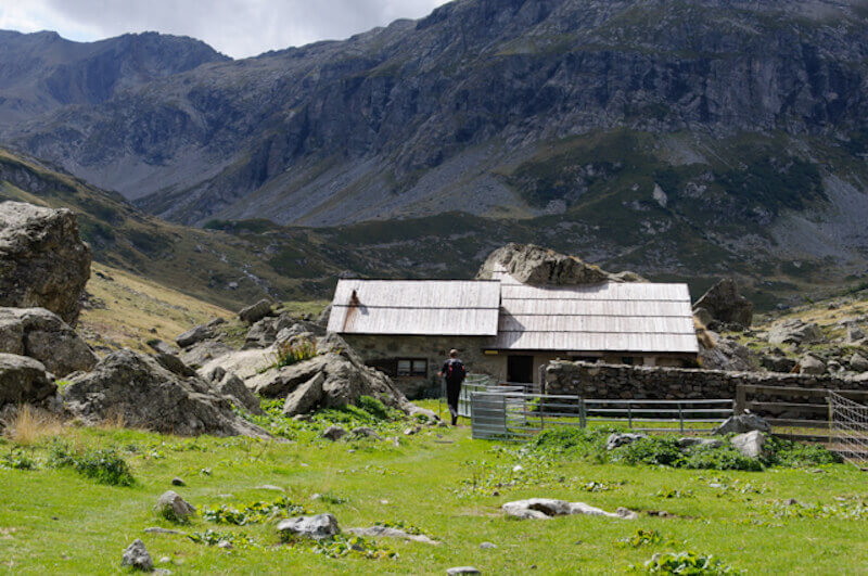
This beautiful walk to the shepherd and bivouac hut Jas Lacroix is ideal for children. The route always follows the banks of the Torrent de la Selle. In this beautiful valley there is no shortage of waterfalls. In the vicinity of the shepherd's cabin there is room enough to enjoy a nice picnic.
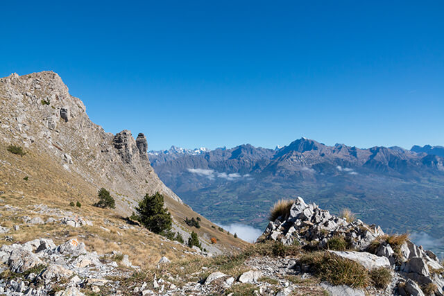
The Valley de Clapouse is a side valley of the Celse Nière. During the walk you always have a beautiful view of the Celse Nière and the imposing Pelvoux. In front of you is the steep wall of the Crête de l'Agulier. When you leave the forest you see a grass hill on the left, this is the Bosse de Clapouse (2179 meters). The view of two of the roughest valleys of the Ecrins is therefore spectacular. The Valley of the Clapouse is also known for the large population of chamois, the chance that you see them is greater if you leave very early. They disappear as soon as the first hikers enter the valley.
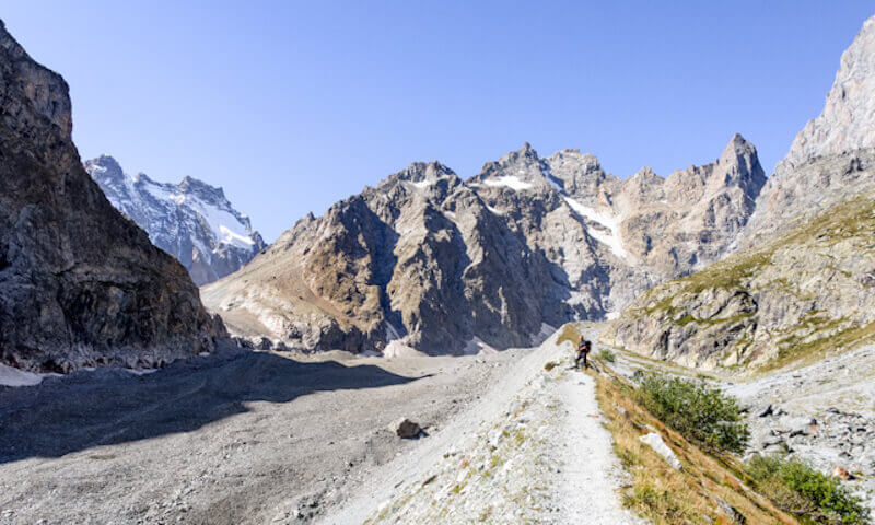
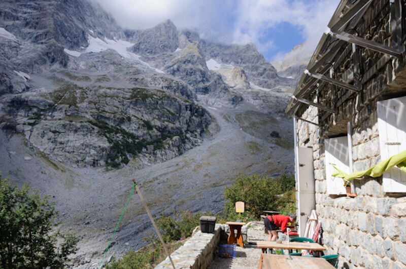
You can call this route special in every way. The Glacier Noir is less known than the route to the Glacier Blanc but it is impressive because of the exceptionally beautiful views of the northern walls of Mont Pelvoux, the Pic Sans Nom, the Pic de Coup de Saber and the Ailefroide Centrale. On the other hand, the walk is also special because you follow the path on the ridge of the moraine to above the Balmes de François Blanc (2469 meters). At the Balmes de François Blanc you can see clearly where in 1979 the Glacier Noir and the ice of the Col des Avalanches were still one glacier mass. The gem tracks on the moraine tell you that this walk makes a meeting with these agile climbers possible in the evening.
This hiking route goes through a rugged valley to the beautifully situated Refuge des Bans at an altitude of 2083 meters. You follow the course of the Torrent des Bans via a stony path. Along the way you come across a swamp and a frog pond, a special place in the high mountains. Once at the top you have a beautiful view of the cirque that closes the valley with the Pic de Bonvoisin, Pic Jocelme, Pic des Aupillous and the Sommet des Bans as a barrier, you can only pass through the Aupillous mountain pass.
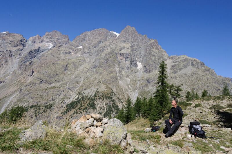
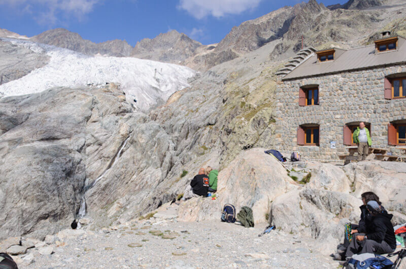
This walking route is an absolute must do if you are in the Hautes-Alpes region. You will never be alone on this hike but you will not be able to reach a glacier so easily anywhere else in that region. From the Pré de Madame Carle refuge you walk to the Ancien Refuge Tuckett. Via a flatter path it continues in the direction of the refuge du Glacier Blanc that you can see from far away. At the refuge du Glacier Blanc, at an altitude of 2542 meters, you can enjoy the view of the Glacier Blanc from one side and the other on the majestic Mont Pelvoux and the Pic Sans Nom.
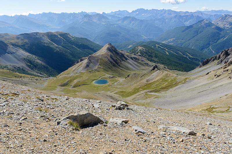
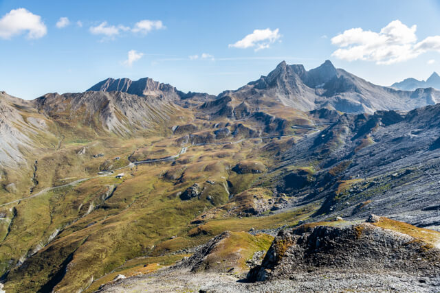
The first part of this route follows the GR58 to the picturesque Lac de Souliers with the Pic de Rochebrune (3320m) in the background. The second part of the hiking route is of a different order, you take the path that goes north-east from the lake to the Pic Ouest at 2817 meters. You have a beautiful panorama on the Casse Déserte with the Ecrins in the background. The famous col d'Izoard is at your feet, as it were. On the other side you can see the Lac de Souliers far below you and the view of the Queyras is stunning.
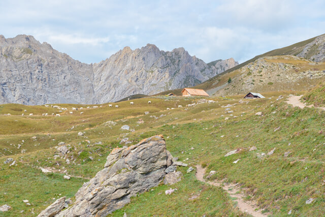
The trail starts at Le Queyron and goes through the forest for a short while, but soon you arrive at a panorama path that runs high above the valley of the Guil and offers a beautiful view of Escoyères and the Chapelle Sainte-Marie Madeleine. You follow the GR 58 further to the Col de la Lauze, this is a tough climb but luckily there are several hairpin bends that help you a bit. After the Col you reach the meadows of Furfande and it goes via a fairly flat path to the Refuge de Furfande. After enjoying a snack or drink on the terrace, return to the starting point via the same route.
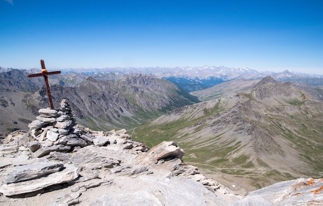
This trail is the classic in the Queyras and you will probably not be alone during the season. When you reach the cross at the top of Pain de Sucre, at an altitude of 3208 meters, you will be rewarded for the effort because the panorama is truly breathtaking. You have a view of the Monte Viso, the Alpes-Maritimes, the mountains of L'Oisans and La Vanoise and in clear weather even the Mont Blanc.
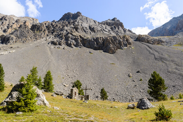
This walk will introduce you to beautiful but rough Val d'Escreins. The route follows the banks of the Rif-Bel to the source called Font Sancte at the foot of the Pics Font Sancte. These two peaks of 3385 and 3371 meters respectively owe their name to the legend of the source. A young shepherdess led her goats in the Val d'Escreins where the best grass could be found on the highest meadows. However, the shepherdess saw no water anywhere and wanted to leave the valley again, but one white goat was not inclined to return. After dusk she followed the goat and the miracle occurred, the fountain of Font Sancte was 'born'.
For a day we neglect the intoxicating scents of resin and humus released by the different types of pine because this part of the Queyras already borders the arid mountains of Briançon. There are still some trees around Clapeyto and Collet, but soon we enter a world of grass where millions of flowers adorn the plains in the spring. From the Col de Néal it goes in the direction of Chalets de Clapeyto, along the way you come across several lakes, on the left side of the path is the Lac de Néal, and on the right you pass the Lacs Marion, Lac de Favière and Lacs du Cogour.
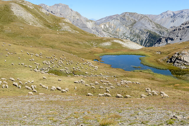
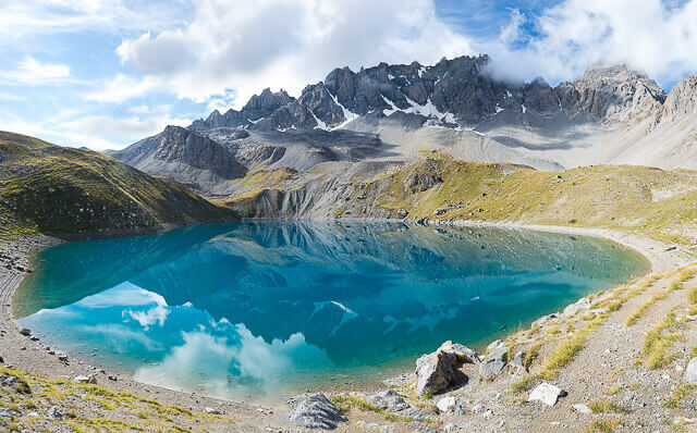
This walking route is divided in two parts, the first part goes to the beautiful glacier lake Lac Sainte-Anne and the chapel of the same name at the foot of the imposing Font Sancte (3385 meters). The second part to the Col Girardin at 2699 meters is a bit more difficult, especially in wet weather the rocky path can be very slippery, but once on the Col you will be rewarded with a beautiful view.
To reach a top of over 3000 meters, you often have to make a greater effort than this route to the Pic de Caramantran at an altitude of 3025 meters. From the Col de Chamoussière you already have a beautiful view of the l'Aigue Agnelle valley and the road to the famous Col d'Agnel. On the other side you have a view of the l'Aigue Blanche valley with the famous Chapelle de Clausis in Saint-Véran in the distance. From the Col de Chamoussière it goes in the direction of the Pic de Caramantran where you really have to take the time to enjoy the view. On the Italian side you can see the Varaïta valley with the Monte Viso (3841 m) as the dominant mountain next to the Pic d'Asti (3220 m).