The imagination of the walker is put to the test during the detour around Zaamslag. In the past centuries the village had a castle with lords of the castle, a commandery with Templars, a hospital and a parish church, but also a brewery and a mill. They have all disappeared. Fortunately, there is still a lot of natural beauty to enjoy.
Distance: 4.8 km.
Time: 1h15.
Grade: Easy.
Type: Circular.
Gps Track: Yes.
Route description: Yes.
Wheelchair: Not suitable.
Dog: Allowed.
Height gain: Flat.
Trail: Paved and unpaved.
Marking: Walking nodes.
Hiking shoes recommended.
Advertisement.
Lords and churches.
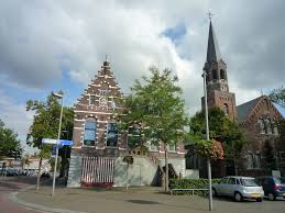
The detour starts in the center of Zaamslag at the former town hall and the PKN church, already the third church on this spot. It is likely that the craftsmen of Zaamslag (Saemslach) who served in the Middle Ages in the Heerlijkheid Zaamslag, founded the first church here. Power and church were strongly linked at the time. With the iconoclasm of 1566 Catholicism disappeared from Zaamslag and after the Eighty Years' War only the castle tower was still standing. The village had to be completely rebuilt. Among other things, the Polderstraat was paved from the ruins of the church.
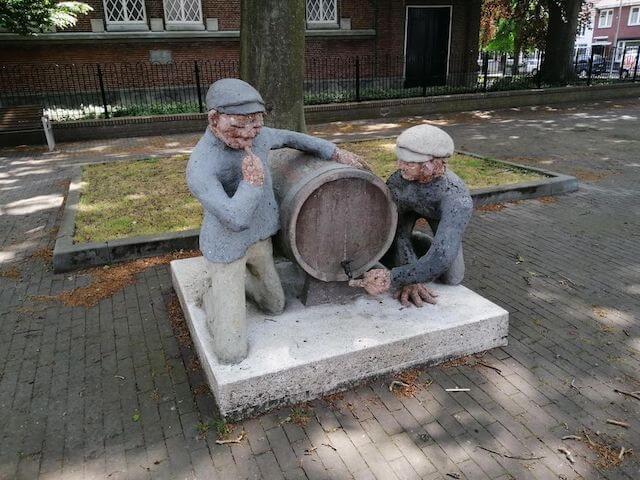
The statue of the Stropelekkers, as the inhabitants are jokingly called, now stands in front of the current church. The story goes that the villagers came en masse to a leaking barrel of syrup, which they feasted on while licking.
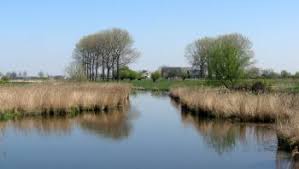
At node 44, on the spot where a post mill once stood (note the gable stone and mill stone), the detour goes to care center De Molenhof - along the village orchard, over a lovely strolling path, straight through reed lands and over a bridge over the Kleine Dulper - towards node 98. Follow the yellow arrows. The Zaamslagpolder, through which you walk, was embanked in 1648 by Gerard van de Nisse, the first Protestant Lord of Zaamslag. At the time, the polder still had 50 landowners!
Just outside the route, but visible as an elevation in the landscape from the Groeneweg, in the thirteenth century stood the imposing Tempelhof and the hospital of the Johanniter Order. Young knights were trained for the Crusades in this extensive monastery complex. The historic site was and is food for archaeologists and history buffs. The route turns left to node 70, along flowering field edges, across the yard of mini camping De Stropelekker, back to Axelsestraat. Via the Brouwerijstraat you will come across the Torenberg, the archaeological protected hill on the edge of the village. Before Zaamslag disappeared under water, there was a real castle here; first a wooden moth castle with outer bailey, later with a brick tower, entrance gate and floating walls. Information boards and a mural show what this must have looked like.
The path around Torenberg is named after one of the current lords of Zaamslag, Gerrit de Zeeuw. If you have time to spare, stop by its impressive Shell Museum, as well as the Minos Museum with its collection of photo cameras, well worth a look.
Download PDf for route description.
POI 1 - Shell Museum.
The Shell Museum is a private museum in Zaamslag, Zeeuws-Vlaanderen. The collection consists of the private collection of the amateur archaeologist Gerrit Johan de Zeeuw and is located at Plein 3 in Zaamslag. The museum consists of two parts: the marine biological flora and fauna section and the archaeological finds section. The marine biology part is known for its great diversity. One of the highlights consists of the skeleton of a bottlenose whale, captured in 1758 as 'the monster of the Hellegat'. The collection of shells comprises several thousand shells.
No additional information.
POI 2 - Minox Museum.
The museum is full of hundreds of minox mini photo cameras and so many attributes. Altogether more than 2000 objects.
No additional information.
POI 3 - Torenberg.
The Torenberg was the castle of Zaamslag, where the craftsmen resided between the twelfth and the sixteenth century. The castle of Zaamslag was probably built in the 12th century. A number of piles found were investigated. During the Eighty Years' War, a large part of the Zaamslag area was flooded for military reasons in 1586. The castle was also flooded, with the exception of the main tower that served as a beacon for the ships. When the area was reclaimed in 1649, the lords built a farm near the ruin. The tower was demolished in 1697, but the hill is still clearly recognizable in the landscape. The Torenberg was and still is much confused with the commandery of Zaamslag, of the Knights Templar.
No additional information.